Lands that are presently collectively known under the name of “Ukraine” had a turbulent history, especially in the last 300 or so years. In this post I want to take a look at a few maps, and present some short historical information, pertaining the term “Ukraine” and how it came to be. I will finish this post with some quite obvious genetic discoveries.
Let us first start with the following 4 maps, and explanation to them, coming strait out of Lada Ray’s excellent Earth Shift Report 2. Ukraine: Truth, Lies & Future Hope. It is a highly recommended, well-researched for-donation report of a size of a small book, for everyone who want to learn what is going on in Ukraine behind the scenes, its history and what lies ahead.
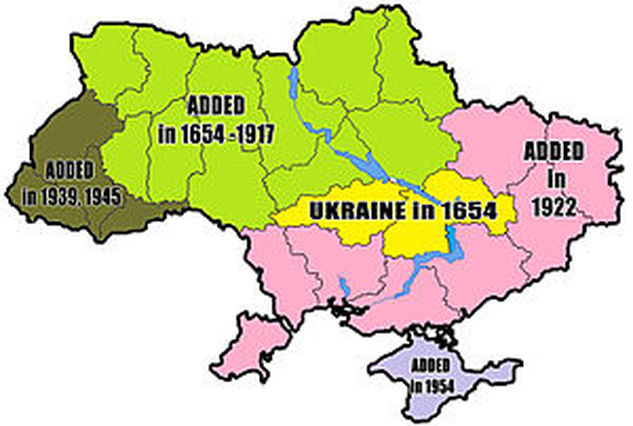
This map shows how the size of Ukraine changed through history. NOTE! What is shown here in yellow as ‘Ukraine in 1654’ was in fact the territory of the Zaporozhie Cossacks (Zaporozhskie Kazaki). There was no country or territory called Ukraine before Lenin and Bolsheviks created the Ukrainian Soviet Socialist Republic as part of the USSR.
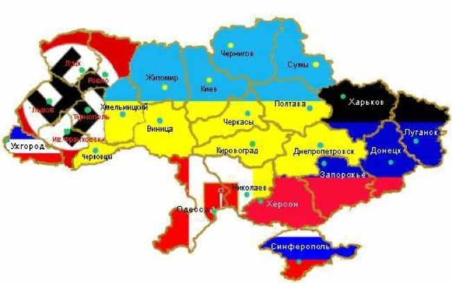
This map shows one of the ideas of how the division of Ukraine should happen by oblast, if it was done in 2014, before civil war began. It shows one big DNR consisting of Donetsk, Lugansk, Zaporozhie, Kherson and Kharkov. For some reason it omits Dnepropetrovsk, which should be within this affinity, but that probably didn’t happen since at the time Kolomoysky was at the helm in Dnepropetrovsk . The center, incl Kiev, remains under Ukraine flag, western Ukraine’s 5 oblasts are obviously under nazi flag. Zakarpatie (Transcarpathia) with Rusins (ruthenians) has its own republic with a flag resembling Russian. Red/white/gold Odessa flag with anchor on it unites Odessa and Nikolaev oblasts (I’d add Kherson and certainly Pridnestrovie, plus possibly Gagauzia – part of Moldova). This kind of voluntary peaceful divorce could have happened if we were dealing with mature people and if Ukraine was a sovereign state, not under foreign occupation.


