
The result of sitting on two chairs with one side of your backside on each chair is well-known, especially when the chairs are steadily moving apart.
Yanukovich barely made it alive in 2014, while Ukraine became engulfed by the Brown Plague which tormented the South-East of the country for long 8 years, before Russia was forced to put an end to it.
Lukashenko waited until a Polish-Ukrainian attempt at a colour revolution was staged in Belorussia, but stood his ground with massive Russian help. He drew the right conclusions about who’s Belorussia’s real friend. Thankfully.
Tokaev faced a colour revolution in Kazahstan and only with the collective help of Russia and the ODKB military block did Kazahstan avoid being plunged into a civil war. One can listen to it in greater detail in Lada Ray’s Earth Shift Report 9: ATTACK ON KAZAKHSTAN. WHO DESTABILIZES EURASIAN UNION?. But it does not seem that he drew any conclusions from that and continues the dual-chair-sitting act. Newly, he tried to please the US/NATO-West by imposing sanctions on Russia in a round-about way, while trying to make it look like he doesn’t. As the result came a mild warning, and the oil export from Kazahstan was suspended “for technical reasons” through the Caspian Sea. (There is a real technical reason for suspension, but the Russian authorities did not look too closely at it before Kazahstan started making destabilising moves in the Southern underbelly of Russia.)
Before the start of the Special Military Operation to free Ukraine from the Brown Plague, President Putin said in his address to the nation – and the World at large – that there are countries that have their statehood and territories thanks to the presents from Russia. It did not apply just to Ukraine, but it seems not all had ears to listen. Even Ukraine can sport a history that is about 60 years longer than that of Kazahstan…
I came across a map from the textbook “History of the USSR” published in 1971, depicting a map of the foundation of the USSR in 1922 and the emergence of the Central-Asian Republics in 1924-1925. I remember this map well, having had a similar textbook in my schooldays.
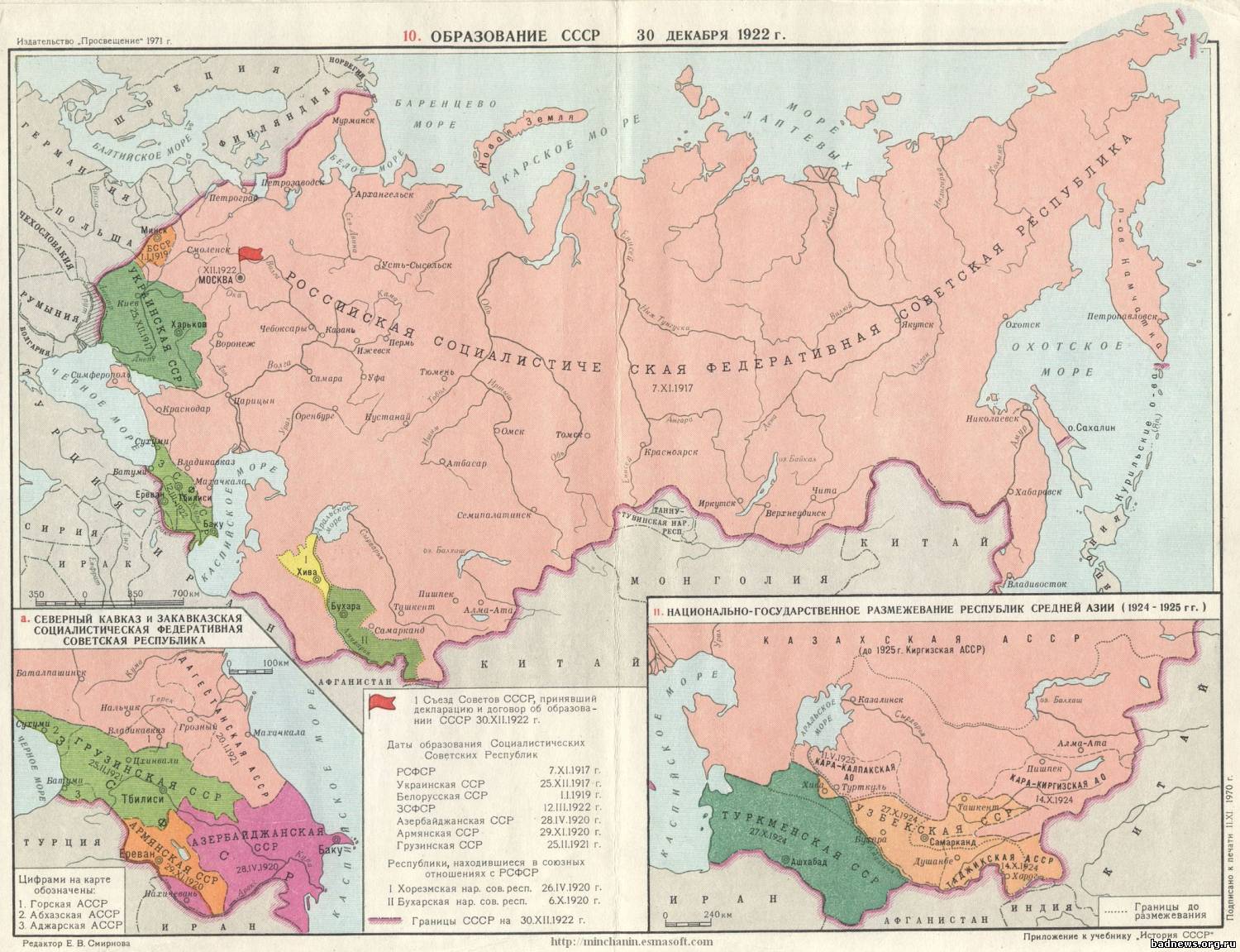
(Click on the map to enlarge)
Let me give a short translation of some parts of the map above:
The big map is the formation of the USSR on the 30th of December 1922, where Russian SFSR was established on the 7th of December 1917, Ukrainian SSR on the 25th of December 1917 with the capital in Harkov. Orange is the tiny Belorussian SSR (01.01.1919) founded on the remains of the Minsk Governorship of the Russian Empire. Between the Black Sea and the Caspian is the Trans-Caucasian Socialist Federative Republic, founded on the 12th of March 1922.
Inset a: Northern Caucasus and the Trans-Caucasian Socialist Federative Republic (ZSFSR): Green is Georgian SSR (25.02.1921) with number denoting Autonomous republics within Georgian SSR: 1 is Mountainous (Gorskaja), 2 is Abhazia, and 3 is Adjaria. Orange is the Armenian SSR (29.11.1920). Purple is the Azerbajdsjan SSR (28.04.1920)
Map 11 inset: The nation-state division of the republics of the Central Asia (1924-1925): Green is Turkmen SSR (present day Turkmenistan) (27.10.1924). Orange, upper part: Uzbek SSR, present day Uzbekistan (27.10.1924). Orange, lower part: Tadsjik Autonomous SSR (present day Tadsjikistan) within the Uzbek SSR (14.10.1924). The pink territory is the Russian SFSR, and within it is the Kazah Autonomous SSR (until 1925: Kirghiz ASSR). In the lower left is the Kara-Kalpaksk Autonomous Region (11.05.1925). In the lower right is the Kara-Kirghiz Autonomous Region (14.10.1924)
The inset with the text and the flag lists several dates:
The First Congress of Soviets of the USSR, which adopted the resolution on the formation of the USSR on the 30th of December 1922.
The dates of the founding of the Socialist Soviet RepublicsRSFSR – 07.11.1917
Ukrainian SSR – 25.12.1917
Belorussian SSR – 01.01.1919
ZSFSR – 12.03.1922
Azerbajdsjan SSR – 28.04.1920
Armenian SSR – 29.11.1920
Georgian SSR – 25.02.1921Republics in a union relationship with the RSFSR:
I. Horezmsk People’s Soviet Republic – 26.04.1920 (Yellow on the big map)
II. Buharsk People’s Soviet Republic – 06.10.1920 (Green below Yellow on the big map)
If one looks closely at the map, there is no such thing as Kazahstan. In fact, the name Kazah Autonomous SSR was adopted first in 1925. Before that the territory was called the Kirgizia (or Kirghiz) Autonomous SSR. And as the name “Autonomous” implies, they were parts of the Russian Socialist Federative Soviet Republic (RSFSR). Kazah itself is a name “borrowed” from Cossacks, the well-known Russian semi-nomadic border guard military settlements which could be found on the whole stretch from the Black Sea and until Urals. The self-name of the Asian nomadic tribes in the Southern part of the Russian Empire was Kirghiz, and it is still the Kirghiz that is the ethnicity of the Kasahs (Incidentally, quite similarly, “Ukrainian” is the name of the Nation, but their ethnicity, which they try to burn out with fire is, in fact “Russian”).
Kazakhstan conducted a strong nationalistic policy, driving out Russian people from the Northern Kazahstan, who lived in the towns there for decades or even centuries (depending n whether the town was built by the USSR or the Russian Empire). Many towns were renamed to Kazah-styled names, like Semipalatinsk on the map above, which in 2007 got renamed into Semej:
From Wikipedia: The first Russian settlement in the area dates from 1718, when Russia built a fort beside the river Irtysh, near the ruins of an ancient Buddhist monastery, where seven buildings could be seen. The fort (and later the city) was named Semipalatinsk (Russian for “Seven-Chambered City”) after the monastery. The fort suffered frequently from flooding caused by snowmelt swelling the Irtysh.
And now they are seeking to give Petropavlovsk, a city built by Catherine the Great and named after Peter I and Paulus I, its “original” Kazah name!
I do hope, for the sake of the young Kazahstan state, that the ultra-nationalism there does not take a deeper root, like it did in another young state that we once knew – Ukraine.
For additional background I would recommend reading a free Lada Ray report: EARTH SHIFT REPORT 1 RELOADED!IS PUTIN PART OF NWO? Astana KZ – New NWO Capital? Bonus: Lukashenko’s Bluff
Pingback: Finnish blogger: That’s why half the world owes Russia to the grave | Nemo's Realms