The twists and turn of lies performed by the US to demonise Russia and to foster Rossophobic sentiment are mind-boggling. In the recent charade, the US released several “sattelite” images of presumable Russia shooting with artillery over border at Ukrainian positions.
Before I go on to the images, I’d like to say a few words about the shelling of Russian territory by Ukraine. This lead to deaths of at least two Russian citizens and destruction of property on Russian soil. In one of the latest event, when criminal investigators came to the scene of shelling, Ukrainian troops did a repeat performance, targeting the team of investigators and journalists. If anything like this happened in the US, the global bully would have retaliated on the spot with an over-dimensioned retributary attack, removing the offending country from the face of the earth. Russia on the other hand limited itself to several warnings. Not surprisingly, none of this was reported by the Western presstitute MSM. In the latest statement, Russia’s foreign minister Lavrov said that any further provocation from Ukraine will be met by force and the firing positions in Ukrain that can be proven firing at Russia will be suppressed by return fire.
The whole situation reminds of the time prior to NATO’s invasion into Yugoslavia. Massive provocations and murder of Serbian population remained unreported by Western MSM, yet as soon as Serbs started to retaliate, the same MSM began trumpeting about mass murders of the US and EU best friends, the Muslims.
Now, the images. Here are two articles reporting on them:
US releases satellite images ‘proving’ Russia is firing into Ukraine
‘Fake’: Russian Defence Min rebuffs US sat image claims
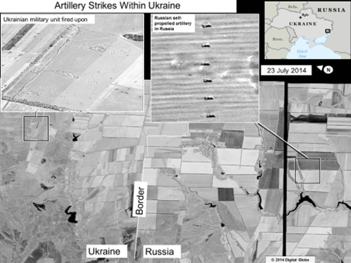
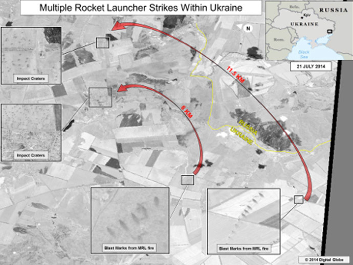
Here are the images in question. Note that all images are labelled as “Artillery strikes within Ukraine”.
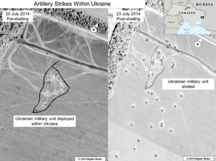
The first and the second image hang together. The first image depicts an alleged Ukrainian unit (which, it’s number, kind, dislocation?) that came under fire. It is another view of the inset from the upper left corner in the second image.
The first question everybody has is: why so low resolution, to the point that it’s impossible to anything on the main images, and one has to believe the insets. Is this the best US can come up with after having spent millions of taxpayers’ dollars on surveillance? GoogleEarth or any other private imagery have better resolution, and are in colour. I doubt that US don’t have high-detail images, it’s just such images would not have shown anything, should they have been released (as Russian Defence Ministry is asking US to do).
The second question is to the tracks in image 1. The artillery units never stay long in one place, especially not in an empty field in the middle of nowhere. They move out to a designated location, perform the task, and move the hell out. So it is natural to assume that the before and after images are at most a few days apart. However, there are fewer tire tracks on the after image, than on before, and the tracks are arranged differently. The tracks could not have disappeared completely after such a short period so as to become completely invisible, which leaves the only other option that the before and after images are many months, if not a year, apart.
The third question is to the impact marks. Many observed that the marks carry a distinct impression of beeing cloned in Photoshop. Second, when firing from a distance of 14km, the angle of impact would have been much more shallow, leading to more elongated impact marks. And third, judging by the existing elongation, the marks are not aligned with the proposed origin of fire and with each other. Consider the following map, superimposed on GoogleEarth image. The yellow line is the direct line to the proposed origin of fire. The red marks indicate the direction, from the individual projectiles came from:

Here is the GoogleEarth image of the area, depicted in the second image, which also marks the distance and direction between the points:

And the fourth question is: why the image of the alleged Russian position in the inset of the second image differes so much from the field in the main image. The stripes in the field would have been visible even at this low resolution, besides, the inst shows on type of field, while its designation box shows two distinctly different fields.
The third image deserves a special attention too. The resolution is so low, that it is almost impossible to make out any detail. The dots in the target zone are only a couple of pixels wide and can be anything. The firing positions of the origin point at a different angle that what their designated alleged targets would be.
Here is GoogleEarth image location of the shot above, with the four inset points marked on the map:
